Hà Tĩnh
You can help expand this article with text translated from the corresponding article in Vietnamese. Click [show] for important translation instructions.
|
Hà Tĩnh | |
|---|---|
| Hà Tĩnh City Thành phố Hà Tĩnh | |
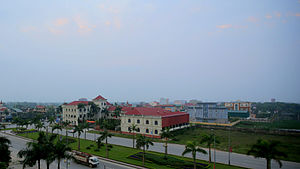
 View from the Sailing Tower building | |
| Coordinates: 18°20′N 105°54′E / 18.333°N 105.900°E | |
| Country | |
| Province | Hà Tĩnh |
| Upgraded to city | 28 May 2007 |
| Government | |
| • People's Committee President | Nguyễn Văn Quý |
| • People's Association President | Hà Văn Trọng |
| • Secretary | Dương Tất Thắng |
| Area | |
• Total | 230 km2 (90 sq mi) |
| Population | 380,000 |
| • Ethnicities | 95% Kinh 5% other ethnicities |
| Climate | Cfa/Am |
| Website | hatinhcity |
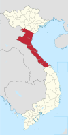
Hà Tĩnh (Vietnamese: [hâː tǐŋ̟ˀ] ⓘ) is a city in Vietnam.[1] It is the capital of Hà Tĩnh Province, and lies in the North Central Coast region. It is located on National Highway 1A. The Vietnamese capital Hanoi is located 340 km north of Hà Tĩnh, Vinh is located 50 km to the north, and Huế is located 314 km to the south. Hà Tĩnh is 12.5 km from the South China Sea.
Geography
[edit]- North borders: Thạch Hà town (via Cày bridge), Cửa Sót river.
- West borders: Thạch Đài Commune, Cày river (Thạch Hà district).
- Southern borders: Cẩm Bình Commune, Cẩm Vịnh Commune (Cẩm Xuyên district).
- Eastern borders: Đồng Môn river (Thạch Hà district, Lộc Hà)
Administrative divisions
[edit]Hà Tĩnh city consists of 16 administration units: 10 wards and 6 communes:
- Nam Hà ward
- Bắc Hà ward
- Tân Giang ward
- Trần Phú ward
- Nguyễn Du ward
- Hà Huy Tập ward
- Đại Nài ward
- Văn Yên ward
- Thạch Linh ward
- Thạch Quý ward
- Thạch Bình commune
- Thạch Trung commune
- Thạch Môn commune
- Thạch Hạ commune
- Thạch Hưng commune
- Thạch Đồng commune
Education
[edit]There are many tertiary education institutions such as Hà Tĩnh University, Hà Tĩnh College of Medicine, Nguyễn Du Cultural, Sports and Tourism College, Hà Tĩnh Vocational College of Technology and Vietnam-Germany College of Vocation. Some high schools include Hà Tĩnh Senior High School, Phan Đình Phùng High School and Thành Sen (Lotus City) High School.
Climate
[edit]Hà Tĩnh has a marginal and unusually wet tropical monsoon climate (Köppen Am) bordering on both an unusually wet humid subtropical climate (Cfa) and a trade-wind tropical rainforest climate (Af) – the last of these being a rare climate type in Vietnam. The heaviest rain is in the northeast monsoon season from September to November, when 1,616 millimetres or 63.6 inches can be expected, but rainfall exceeds 50 millimetres or 2 inches even in the driest months of the “spring” season. The weather during the “winter” season from December to February is warm, humid and somewhat rainy, whilst the “summer” from May to August is hot to sweltering although drier than most of Indochina due to the influence of the mountains to the southwest.
| Climate data for Hà Tĩnh | |||||||||||||
|---|---|---|---|---|---|---|---|---|---|---|---|---|---|
| Month | Jan | Feb | Mar | Apr | May | Jun | Jul | Aug | Sep | Oct | Nov | Dec | Year |
| Record high °C (°F) | 34.5 (94.1) |
36.2 (97.2) |
39.4 (102.9) |
43.2 (109.8) |
41.5 (106.7) |
40.1 (104.2) |
40.7 (105.3) |
39.7 (103.5) |
38.5 (101.3) |
35.2 (95.4) |
35.3 (95.5) |
30.4 (86.7) |
43.2 (109.8) |
| Mean daily maximum °C (°F) | 20.5 (68.9) |
21.2 (70.2) |
23.9 (75.0) |
28.5 (83.3) |
32.4 (90.3) |
34.1 (93.4) |
34.3 (93.7) |
33.1 (91.6) |
30.8 (87.4) |
27.9 (82.2) |
24.8 (76.6) |
21.7 (71.1) |
27.7 (81.9) |
| Daily mean °C (°F) | 17.6 (63.7) |
18.5 (65.3) |
20.8 (69.4) |
24.6 (76.3) |
28.0 (82.4) |
29.7 (85.5) |
29.8 (85.6) |
28.8 (83.8) |
27.0 (80.6) |
24.6 (76.3) |
21.7 (71.1) |
18.7 (65.7) |
24.2 (75.6) |
| Mean daily minimum °C (°F) | 15.7 (60.3) |
16.8 (62.2) |
18.9 (66.0) |
22.9 (73.2) |
24.9 (76.8) |
26.5 (79.7) |
26.4 (79.5) |
25.8 (78.4) |
24.5 (76.1) |
22.3 (72.1) |
19.7 (67.5) |
16.7 (62.1) |
21.7 (71.1) |
| Record low °C (°F) | 5.6 (42.1) |
8.0 (46.4) |
8.2 (46.8) |
13.3 (55.9) |
17.3 (63.1) |
19.5 (67.1) |
22.0 (71.6) |
22.3 (72.1) |
17.0 (62.6) |
15.1 (59.2) |
11.3 (52.3) |
6.8 (44.2) |
5.6 (42.1) |
| Average rainfall mm (inches) | 95.9 (3.78) |
59.8 (2.35) |
61.3 (2.41) |
78.0 (3.07) |
152.5 (6.00) |
138.7 (5.46) |
114.1 (4.49) |
231.9 (9.13) |
525.6 (20.69) |
728.0 (28.66) |
312.2 (12.29) |
159.8 (6.29) |
2,651.4 (104.39) |
| Average rainy days | 15.0 | 14.9 | 15.0 | 11.2 | 11.0 | 8.5 | 7.8 | 11.6 | 14.8 | 18.0 | 15.6 | 13.9 | 157.5 |
| Average relative humidity (%) | 89.9 | 91.3 | 90.4 | 87.0 | 80.5 | 74.8 | 73.4 | 79.3 | 85.1 | 87.3 | 87.4 | 87.3 | 84.4 |
| Mean monthly sunshine hours | 70.7 | 53.0 | 73.1 | 135.8 | 219.3 | 210.8 | 226.5 | 191.8 | 156.5 | 129.5 | 94.4 | 73.5 | 1,629.6 |
| Source: Vietnam Institute for Building Science and Technology[2] | |||||||||||||
Gallery
[edit]-
City Cultural Center
-
Hà Tĩnh commercial center
-
Trần Phú Park
-
A corner of Hà Tĩnh City
-
City cultural house
-
Vincom Plaza, Hà Tĩnh city
-
Vinhomes Hà Tĩnh area
-
Xuân Diệu - Nguyễn Du intersection, Hà Tĩnh city
See also
[edit]References
[edit]- ^ Atlas of the World, Oxford University Press, 2011, p. 236.
- ^ "Vietnam Institute for Building Science and Technology" (PDF).


